GROUNDWATER BASIN &
SUBBASIN STUDIES
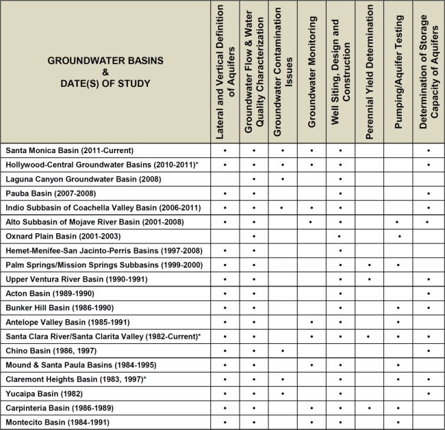
DESCRIPTION OF GROUNDWATER BASIN & SUBBASIN STUDIES
Santa Paula Basin, Ventura County (2014-2016)
RCS provided an independent and detailed definition of a hydrogeologic conceptual model of the Santa Paula Groundwater Basin to help better understand the hydrogeology of the basin, and to describe the movement of groundwater into and through the basin. To do so, RCS created detailed hydrogeologic cross sections of the basin by correlating key marker beds detected on available geophysical electric logs of oil wells, production water wells, and monitoring wells. Using those subsurface interpretations, and groundwater elevation data, RCS calculated the estimated amount of groundwater underflow that entered and exited this groundwater basin. Ultimately the work was used to help re-calculate the safe yield of the groundwater basin.
Santa Monica Basin, Los Angeles County (2011 - Current)
Available historic data and information with regard to geologic and hydrogeologic conditions, well locations and construction, water levels and water quality were reviewed and analyzed with the objective of establishing a conceptual model of the groundwater basin and assessing the overall storage capacity of the basin. Important in this study was the use of electric logs to define the geometry and lateral and vertical extent of important aquifer systems and locating sites within the City of Santa Monica for the construction of new municipal-supply water wells. Current work includes: depth-discrete sampling and testing of selected active wells; selecting viable well sites and providing the preliminary design for new City wells.
Hollywood-Central Basins, Los Angeles County (2010-2011)
Detailed hydrogeologic studies in the highly urbanized Hollywood and Central Groundwater Basins were conducted to provide recommendations for new municipal-supply wells. Definition of water quality problems by hydrogeologic methods was conducted because of known mineralogical and bacteriologic problems. Much of the work was based on detailed analyses of considerable amounts of subsurface oil well data which provided the key to identifying the geologic structure of the basin. Site locations and designs for future test holes and water wells were also provided. Other work over time has involved sampling and evaluation of shallow groundwater being collected in active sumps beneath subterranean parking garages, field monitoring and down-hole sampling of exploratory test holes, developing a detailed groundwater monitoring management plan for the City, and evaluating problems in active City wells.
Mr. Slade’s initial large-scale project in Hollywood Groundwater Basin, and the La Brea Subarea of the Central Groundwater Basin, was conducted in 1972 -1974 while he was with a private consulting firm. That initial work included pumping tests and water level monitoring of then-existing wells, correlating electric logs from numerous oil/gas wells, providing an interpretation of subsurface conditions and groundwater flow directions, and providing a perennial yield evaluation of Hollywood Groundwater Basin.
Recent work includes the siting, design, down-hole testing, construction monitoring and aquifer testing of 2 new shallow water wells for the City; the recommended locations and depths for these 2 wells were selected by RCS to help preclude water level drawdown interference with the City’s four active, deep, water wells. Recent work also includes an updated analysis of subsurface conditions in the La Brea Subarea, an area within the unadjudicated Central Groundwater Basin. Specifically, this Subarea lies directly south of the unadjudicated Hollywood Groundwater Basin, and just north of the northern limits of the adjudicated portion of the Central Basin. Also part of this new work is the selection of potential locations for 3 to 4 new municipal-supply wells in La Brea Subarea, preparation of Technical Specifications and Bid Sheets, field monitoring of the various elements of well construction, and the monitoring for and analysis of the final pumping tests in each new well.
Laguna Canyon Groundwater Basin, Orange County (2008)
This is a small groundwater basin that was evaluated for the Laguna Beach County Water District and, in many ways, mimics the groundwater conditions of alluvial and bedrock aquifer systems of a mountain area; a relatively shallow and limited alluvial groundwater aquifer system and a deeper and much more extensive fractured sedimentary bedrock aquifer system which has, because of its limited storage capacity and reduced permeability, only a poor ability to effectively transmit water. In this study, available historic hydrogeologic, water well, water level, and water quality data were evaluated for the purpose of selecting potential new well sites to help supplement and expand the current capacity of the District. This, coupled with field reconnaissance of the watershed area, led to the selection of several potential new drill sites.
Pauba Basin, San Diego County (2007-2008)
In this project, RCS geologists obtained substantial historic and current paper data and electronic files from the Rancho California Water District (RCWD) for a significant hydrogeologic characterization of their Pauba Groundwater Basin. RCS provided the first-ever and independent correlation of available electric logs (E-logs), defined key marker beds in the subsurface, assessed the locations of wells and monitoring wells, prepared detailed cross sections using the marker bed correlations, and evaluated water quality changes across the basin using Stiff water quality pattern diagrams.
Coachella Valley Basin, Indio Subbasin, Riverside County, California (2006-2011)
RCS performed a groundwater basin evaluation of the Indio Subbasin of the Coachella Valley Basin for the Indio Water Authority (IWA) with the objective of selecting new well sites for this water purveyor. This study involved the hydrogeologic elements of the correlation of electric logs, definition of aquifer continuity, down-well testing of fluoride in existing wells, preparation of Technical Specifications for well construction, and final design and monitoring of the construction of three new municipal-supply water wells for the IWA.
Alto Subarea, Mojave Groundwater Basin, San Bernardino County (2001-2008)
The major study of the Upper Mojave River Channel was performed for the Mojave Water Agency's (MWA) Regional Recharge and Recovery Project. During this study, RCS geologists worked closely with GIS and data managers from the MWA to compile and review electronic and paper files to create a large-scale database for the entire Alto Subarea. This database included all well locations, drillers' logs, electric logs (E-logs) and pumping data. An FTP repository was also created and used as a major data interflow between RCS and MWA. RCS also provided detailed and independent geologic analyses and correlation of approximately 345 E-logs, and selected bedrock "picks" for an additional 225 wells in the subarea; the database included roughly 900 wells.
Commencing in 2001 and prior to the major MWA study, RCS performed several independent evaluations of subsurface hydrogeologic conditions throughout the Alto Subbasin region of the Mojave River Basin, which were followed by the design, construction and testing of several water-supply wells for Victor Valley Water District (now Victorville Water); City of Hesperia; Baldy Mesa Water District (now Victorville Water); City of Adelanto; Rancho Las Flores; and the High Desert Power Plant Project (HDPP).
Oxnard Plain Basin, Ventura County (2001-2003)
In 2002, RCS conducted a comprehensive evaluation of the Oxnard Plain Groundwater Basin for the City Oxnard for the purpose of selecting potential new sites for municipal-supply water wells. In addition, an evaluation of the existing water-supply wells for the City was also performed to establish the physical condition of each well and determine which wells could be replaced and/or destroyed. These studies were followed by the bidding, design and field monitoring construction of three new wells and bidding and field monitoring of the rehabilitation of three other City wells.
Hemet-Menifee-Perris-San Jacinto Basins, Riverside County (1997-2008)
Several studies in each of these groundwater basins were conducted for the Eastern Municipal Water District (EMWD), between 1997 and 2008, for the purpose of evaluating the available groundwater resources of this region. These studies brought together work performed by RCS on several water well and exploratory test hole drilling and/or construction projects with available data obtained from EMWD to help characterize and locate sources of groundwater. From these data, correlation of electric logs was performed and geologic cross sections were generated to help reveal the hydrogeologic conditions and general geometry of the basins.
Palm Springs & Mission Springs Subbasins, Riverside County (1999-2000)
This major study of the basins underlying Palm Springs was conducted to: define the areal extent and vertical depth of the groundwater-bearing sediments; identify potential sources of bacterial precipitates in a few active wells; define the locations and designs for new, high-capacity wells. Hydrogeologic work included: data research; updating of water level and specific capacity data by field work and aquifer tests of select wells; determining the three-dimensional configuration of the basin and the continuity of aquifers; calculating the total and usable amounts of groundwater in storage; determining aquifer characteristics; assessing existing computer model data; defining fault-related groundwater barriers; and assessing the potential impacts of continuing water level declines on existing wells.
Ventura River Basin, Ventura County (1990-1991)
A detailed study of this major groundwater basin was conducted as part of a comprehensive Environmental Impact Report for a site in the basin. Work conducted during this study included: establishment of base-period hydrologic conditions; review, compile, and analyze hydrologic and hydrogeologic data collected from various water agencies in the area; analysis of temporal changes in water levels and water quality in the basin; analysis of temporal changes in groundwater extractions in the basin; calculation of basin groundwater storage and the potential impact of additional groundwater extractions from the basin on groundwater levels, groundwater in storage, other groundwater extractions, and groundwater quality; impact of surface water flows in the Ventura River and the impact of groundwater extractions on these flows; and assessment of various impacts and potential mitigation measures for the proposed project.
Acton Basin, Los Angeles County (1989-1990)
Geologically identify the surface extent of the alluvial deposits and terrace deposits which comprise this groundwater basin. Identify the approximate maximum thicknesses of these materials. Prepare hydrographs of key wells and analyze the historic fluctuations in water levels vs. time and vs. the long-term rainfall record in the area. Provided detailed calculations of groundwater in storage in each of the two aquifer systems, identified locations for future municipal-supply water wells, and assessed the magnitude of annual recharge to the basin.
Bunker Hill Basin, San Bernardino County (1986-1990)
A detailed hydrogeologic study of the Upper Bunker Hill Basin, in the vicinity of the City of Redlands, was performed to eventually define new municipal well sites. Major concerns for the potential well sites were proximity to active faults, shallow thicknesses of water-bearing sediments, extremely difficult drilling conditions due to the abundance of boulders and cobbles, contamination from volatile organic compounds like TCE, PCE, and DBCP (a fumigant), and nitrates (due to the citrus industry). Drill sites were selected, local wells were sampled and monitored, and detailed Technical Specifications for well construction were prepared. Several new municipal-supply wells were drilled under our technical specifications, with our field geologists providing geologic logging, monitoring of casing/gravel pack installation and monitoring of all well development and final pumping tests. Electric log interpretation defined well screen placement.
Later on, as part of a major groundwater litigation case, RCS collected and reviewed masses of groundwater data for the entire Bunker Hill Basin. Active water wells were identified; their history of annual groundwater extractions was evaluated vs. historic water level fluctuations. Annual extractions by various agencies were graphed and compared, and then reviewed in terms of long-term rainfall trends. The history of artificial recharge (spreading) was evaluated relative to resulting water level impacts on the basin and to the locations of active downstream water wells. Correlations of individual aquifers were made using available electric logs, and cross sections were prepared along with geologic maps to help evaluate the 3-D configuration of the groundwater reservoir.
Antelope Valley Basin, Los Angeles County (1988-1991)
A series of detailed groundwater investigations in various portions of this large groundwater basin, which included numerous tasks such as: collection and review of subsurface data; detailed correlation of electric log signatures together with evaluation of drillers' logs to provide an accurate assessment of the location and continuity of the "blue clay" and of granitic basement rocks underlying the groundwater reservoir; providing optimum well locations and designs for new wells; evaluating water quality in specific aquifers; monitoring construction; geological logging of drill cuttings and review of E-logs; and conducting aquifer tests of completed wells.
Santa Clara River & Santa Clarita Valley Basin, Los Angeles County (1987-1988)
This detailed study examined the hydrogeologic characteristics of the alluvial aquifer system of the Santa Clara River; also evaluated were the characteristics of the underlying Saugus Formation. Work included determining groundwater flow direction, current water levels and levels at the beginning of our selected hydrologic base period, water quality assessments, review of annual and historic groundwater production by well and by aquifer system, calculations of groundwater in storage for various time periods, quantification of the perennial yield based on the change-in-storage method, calculations of recoverable water from 13 major tributaries, and determination of sites for future artificial recharge basins
Chino Basin, Los Angeles and San Bernardino Counties (1986, 1997)
The basin represents one of the largest groundwater basins in southern California and was studied to evaluate its potential, from a hydrogeologic standpoint, to accept recharge of 30,000 acre-feet per year of reclaimed water from local wastewater treatment facilities. Detailed hydrogeologic maps and cross sections were prepared along with contour maps of current and historic water level and water quality (total dissolved solids and nitrate concentrations). Long-term water level hydrographs and water quality chemographs were prepared and compared together with precipitation data. The surface definition of the basin was revised using fault-related groundwater barriers. Other important products included a depth to groundwater map, definitions of groundwater in storage zones in the basin, calculations of potential storage volumes in the unsaturated zone for reclaimed water, and maps depicting potential sites for new spreading basins, spread pump-back schemes, and injection wells.
Mound & Santa Paula Basins, Ventura County (1984-1995)
Studies of each of these two basins were conducted to verify the horizontal extent and vertical depth of the groundwater reservoir, to provide for monitoring of water levels and quality in deep, unexplored aquifers, and to provide the locations and designs of new production wells. Significant portions of the work for these studies involved designing, providing technical specifications, and geologically logging test holes to depths up to 3000 feet. Down-hole tests were conducted to obtain water samples for water quality characterization. Subsequent work has involved considerable expert witness work concerning results of the study.
Claremont Heights Basin, Los Angeles County (1983, 1997)
A hydrogeological evaluation of this basin and of its nearby basins that are separated from one another by faults and/or water level barriers was performed. Groundwater flow directions, historic and current water levels and water quality were identified, and sites for new high-capacity wells to supply a treatment facility were identified. The impact of the new extractions on basin-wide water levels was evaluated, as were related effects on all proximal active wells. Aquifer test data were reviewed and realistic values for transmissivity and storativity were identified. Groundwater in storage was calculated for the several adjoining groundwater basins.
Yucaipa Basin, San Bernardino County (1982)
A major hydrogeologic study of Yucaipa Basin and its adjoining fault-induced subbasins was conducted by RCS. Work included defining the lateral and vertical depths of the basins, correlating well logs, defining fault-barrier effects on water levels and quality, calculating the amounts of recoverable water from local major tributary watersheds, and identifying methods and sites for artificial recharge operations. Calculations were also made of groundwater in storage in the various subbasins for different periods of time. Aquifer parameters of transmissivity and storativity were also evaluated; future well sites and drilling methods were established.
Carpinteria Basin, Santa Barbara County (1980-1987)
A long-term study involving several phases and tasks in order to define groundwater conditions in the basin and to determine the optimum sites for new water-supply wells. Included in the study were: providing correlation of boring logs and electric logs of water and oil wells; collection, analyses, and updating of water quality and water level data; recommending a basin-wide subsurface drilling exploration program; conducting a basin-wide water well survey to obtain well characteristics and well efficiencies; preparing elevation contours on four major aquifers encountered during test hole drilling to depths of 1500 feet; selecting sites, designing, and preparing technical specifications for new wells; detailed geologic logging of all test holes and wells; assessing the safe yield of the basin; providing monitoring and control of all well completion, well development and well testing operations done by the drilling contractor; and detailed aquifer testing and quantitative analyses of aquifer characteristics. Drilling exploration utilized multiple-aquifer techniques and air-lifting methods to obtain water samples.
Montecito Basin, Santa Barbara County (1984-1991)
Several phases of work were recommended and ultimately completed to evaluate the three-dimensional configuration of this coastal basin. Specifically identified were the location, nature, and continuity of potential aquifers; the locations of several fault-induced groundwater barriers and their effects on groundwater quality and seawater intrusion; and the quantitative evaluation of aquifer characteristics based on aquifer tests. A test hole drilling exploration program was conducted to update limited subsurface data; several wells were subsequently located, designed and drilled; and two older wells were redeveloped and rehabilitated. In addition, consultation was provided as needed, and test holes drilled for potential use as bedrock wells.
An additional, separate comprehensive and detailed assessment and investigation encompassed a perennial yield study for the basin. Work for this study included: examination and assessment of temporal changes in water levels in water wells throughout the basin and the impact of these changes on future water supply; calculation of potential groundwater in storage and temporal changes in this storage; selection of a hydrologic base period of analysis; and determination of groundwater in storage versus annual groundwater extraction by all pumpers in the basin.